The complete map of the descents of the Ardèche

Check out the different Ardèche river descents we offer on the map.
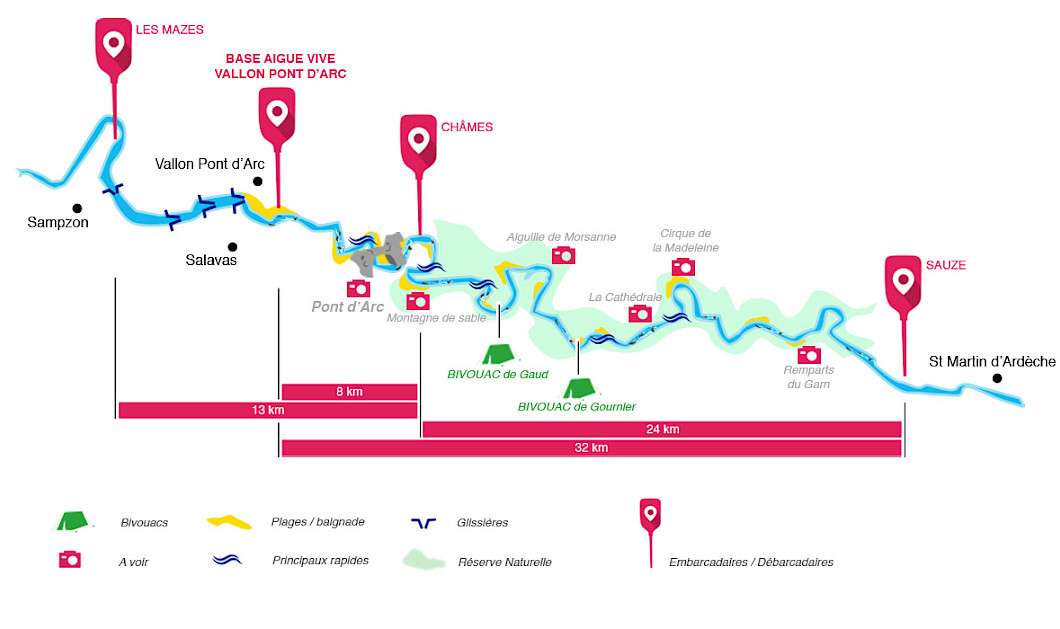
Whether you're a beginner or looking for some thrills, our Ardèche descent map helps you easily choose your route. With this Ardèche gorges map, you'll spot distances, starting points, and all the practical info for a great canoeing day.
We offer 3 types of canoe and kayak descents on the Ardèche
Easy canoe routes to discover the Ardèche river descent
The 8 km descent is ideal for a relaxing half-day on the water, including the famous Pont d’Arc passage. If you want something a little longer and more fun, the 12 km descent includes a few natural slides (canoe chutes) to spice things up!
These routes are clearly marked on our Ardèche descent map to help you make your choice easily.
Sportier canoe descents through the Ardèche gorges
If you're looking for a bit more pace, head into the Ardèche gorges! Between cliffs and wild nature, the 24 to 32 km routes take you through a breathtaking landscape. The 24 km descent goes through the entire nature reserve but does not pass under the Pont d’Arc.
For a full Ardèche gorges descent, the 32 km route includes both the reserve and the Pont d’Arc in one sporty day (about 6.5 hours of paddling).
All these routes are shown on our Ardèche gorges map to help you plan your trip.
2-day canoe descent with overnight bivouac in the Ardèche gorges
Want to make the most of your experience? Go for a two-day adventure! The 32 km descent with bivouac lets you take your time, swim, enjoy an evening by the water... and sleep in the heart of the gorges! (approx. 3 hours of paddling per day)
Our Ardèche gorges map shows bivouac areas and key route points for easy planning.
Need more info or want to book your descent? Get in touch with us, we’ll be happy to help!
Discover the Ardèche gorges by canoe kayak, in the best conditions of safety and pleasure
Aigue Vive, canoe rental since 1987

Discover the Ardèche gorges by canoe and kayak in the best conditions of safety and pleasure
![]()
![]()
Address
Location de canoë Aigue Vive
238 Route des Gorges
07150 Vallon Pont d’Arc
![]() 7j/7 de 8h00 à 20h00
7j/7 de 8h00 à 20h00